

TONIGHT: Clear skies, calm winds, temps in the upper 40s and low 50s
TOMORROW: Continuing our gradual warming trend — lots of sunshine with temps in the low to mid 70s
THIS WEEK: Staying dry, temps staying in the 70s all week, with barely a breeze to speak of
___________________________________________________________
The first day of February saw beautiful conditions with temperatures in the 70s across much of Southern Nevada, and the forecast the rest of the week will look extremely similar.
Before we get too much further with our February forecast, we need to wrap up January!
WATCH | Guy Tannenbaum breaks down January 2026's weather in Las Vegas
January 2026 will go down as the fifth warmest January on record in Las Vegas, since records began in 1937, according to our friends at our National Weather Service office: our average temperature in January — combining both daytime highs and overnight lows — was 52.1°.
We saw only three high temperatures below normal, on January 1, 9 and 10, with 14 days above average — nearly half the month!
As far as rainfall goes, we officially only saw 0.14" of measurable precipitation at Reid Airport in January, which is 0.42" below normal — that's nearly half an inch shy of where we should be!
So, January was warmer and drier than normal, and at this point we're not seeing any signs of a switch up as we enter February.
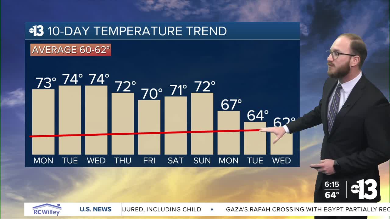
Daytime highs this week will remain in the 70s — topping out near 75° by mid-week for many of our neighborhoods — while overnight lows will be in the upper 40s and low 50s. Our average highs for this time of year are 60° and 61°, so that means our daytime high temps will be anywhere between 10 and 15 degrees above normal.
We'll also be staying dry with calm winds this week to go along with the warmer than normal temperatures — perhaps an increase in winds Tuesday and Wednesday along the Colorado River Valley, Lake Havasu and Lake Mojave, but should still be a non-factor — thanks to a big time ridge of high pressure hovering over the western U.S. into the weekend.
We could see a pattern shift as we look towards next week, though, as an offshore low pressure system moves east off the Pacific Coast and over the Desert Southwest.
That would cool our temperatures down and mark a return of precipitation chances to the region, although that's still more than a week away and details on that particular system remain murky at this point — we'll get a better idea as it gets closer.
As we start the first work week of February, we'll be greeted by the prognostications of a certain rodent in Pennsylvania — that, of course, being Punxsutawney Phil on Groundhog Day.
I've made my disdain for that particular rodent and his phony baloney meteorological qualifications quite clear over the last year, because we have our very own spring prognosticator here in the desert — our celebrity desert tortoise Mojave Max!
WATCH | Monday marks Groundhog Day, but we have something even better in Southern Nevada: Mojave Max!
Mojave Max lives at the Springs Preserve, and is currently brumating in his burrow — that's a reptile's version of hibernation. When the temperatures get warm enough to wake Max up from his slumber, he emerges from his burrow, which is the sign that spring has sprung in the desert!
Local elementary school students have been guessing when Max will emerge from his burrow for more than 25 years in the "Mojave Max Emergence Contest," which is still going strong this year. The winning student wins prizes, a field trip to the Springs Preserve and a pizza party for their class!
Last year was Max's latest emergence in the contest's 25-year history — May 8, just after 2 p.m.!
You can still submit your guess if you haven't already! Just visit mojavemax.com, which you can do by clicking here.