

TODAY: Calmer winds but still breezy, gusts near 25 mph with temps in the low 50s
TONIGHT: First freeze warning of the season—sub-freezing temps through neighborhoods made to feel even colder thanks to wind chill; protect pets, plants and pipes!
THIS WEEKEND: Starting a warming trend through next week, highs in the mid to upper 50s with more sunshine and calmer winds
LOOKING AHEAD: Dry and mostly clear with warmer than normal temperatures near 70° by mid-week
____________________________________________________
After an extremely windy Thursday, winds have calmed down a bit but will still play a role in today's forecast, with strong winds and cold wind chills through Friday and into Saturday early morning.
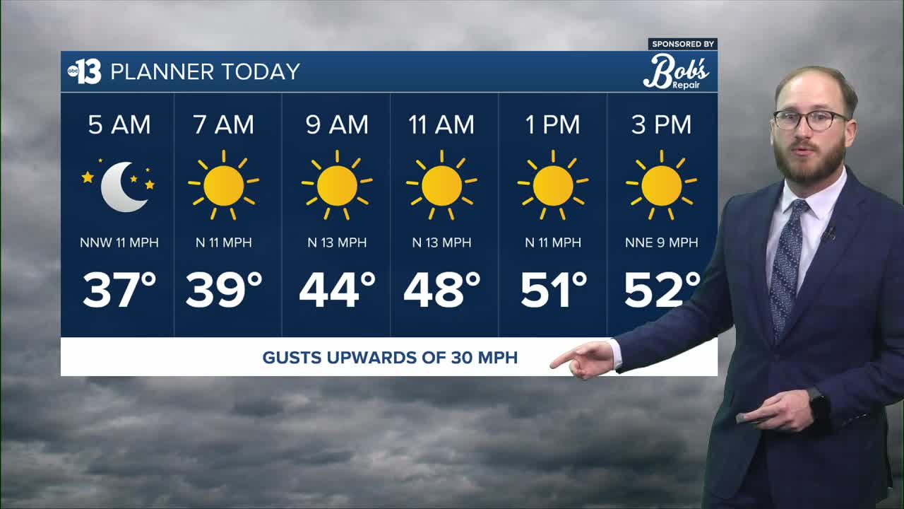
Make sure you have your jacket with you as you're stepping out the door this morning, because we'll be staying in the 40s until lunchtime, with wind gusts between 20-30 mph possible through the early afternoon—not quite enough to trigger any wind alerts, but they'll still be a nuisance throughout your day today.
The good news is that the winds are in the process of winding down, and should be relatively calm overnight tonight and into tomorrow.
Our main weather story is transitioning from the winds to the cold—we have the first freeze warning of the season on the way for Las Vegas overnight tonight, thanks to sub-freezing temperatures through our neighborhoods.
WATCH | Guy Tannenbaum breaks down Friday night's freeze warning
The freeze warning is in place from 2-8 a.m. overnight tonight and into tomorrow early morning, so before you go to bed tonight be sure to protect the "three P's": your pets (bring them inside!), your plants and your pipes, since they're the things most susceptible to cold weather damage.
Significant wind chills overnight will make it feel even colder than your thermometer will show, too. Our models are showing overnight low temperatures in the low to mid 30s, but wind chills will make it feel like the low to mid 20s in places on the edges of the valley like Centennial Hills, West Summerlin, Mountain's Edge and Inspirada.
Once we get through tonight, we kick off a gradual warming trend back to above normal temperatures for mid-January!
Our weekend looks spectacular—still a little chilly with highs in the mid to upper 50s through our neighborhoods, with more sunshine and much calmer winds.
We're staying dry as we start next work week, with mostly clear skies and highs warming to the doorstep of 70° by the middle of the week.
Stay warm, and have a great weekend!
