

MORNING: Wake-up temperatures in the mid 50s to low 60s around Las Vegas with light breezes and a sunny sky.
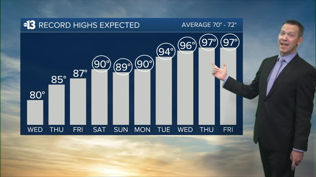
AFTERNOON: The warmest day we've had in more than a week. Expect light breezes with sun and highs near 80°.

EVENING: Sunset is 6:45 p.m. and we'll drop from the 70s into the 60s by 9:00 p.m. with a clear sky and light winds.
TONIGHT: Lows in the upper 50s with clear, calm conditions.
Thursday sees sunshine, light breezes, and a high of 85° (the record is 86° from 2017).
Friday climbs to 87° with some afternoon clouds and 5-10 mph breezes.
Record highs will fall this weekend and especially next week as an intense March warm-up develops across the southwest corner of the country.
We're forecasting a record-setting 90° Saturday, 89° Sunday, 90° Monday, 94° Tuesday (St. Patrick's Day), 97° Wednesday and Thursday, and 94° next Friday. The all-time March record high is 93°, so we'll surpass that benchmark several times next week.
Spring officially begins at 7:46 a.m. on Friday, March 20th.

The UV index is "high" from 11 a.m. through noon, meaning a sunburn could happen in 30 minutes for some people, so grab a hat and sunscreen if you're outside from mid-morning to mid-afternoon (9 a.m. to 3 p.m.).
Forecast pollen levels are "extreme" today and "high" the next several days as trees bloom. Across the valley, ash, juniper, and elm are the predominant pollen types. Showering and changing after you've been outdoors, keeping windows closed when it's windy, and vacuuming and dusting will help.
The air quality forecast is "moderate" due to particle pollution, which tends to accumulate when we have light winds, cool nights, and mild days.
