

AFTERNOON: Mostly cloudy with mid 80s and a 60% chance for showers and thundershowers.
TONIGHT: Mostly cloudy with 70s this evening and a 40% chance for showers and thundershowers.
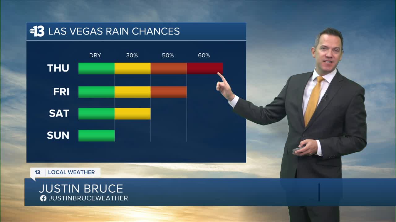
Rain chances today (60%) and Friday (50%) yield occasional downpours with lightning, but there will be plenty of breaks in the rain. The chance lingers at 30% on Saturday.
The wet pattern results from moisture streaming into the Desert Southwest from Tropical Storm Priscilla in the eastern Pacific near the Baja Peninsula.
Rain totals in Las Vegas range from 0.25" to 0.50" over the next three days. While brief, minor flooding issues are possible underneath some of the heavier downpours, widespread problems are not expected in the valley.
The Spring Mountains may see 1" or more of rain, and are now included in a Flood Watch until 11 p.m. Saturday alongside Lincoln County, parts of Southern California, much of Utah, and Arizona.

Temperatures trend from the mid 80s today to the low 80s Friday and Saturday, then upper 70s Sunday and Monday.
Sunshine returns Sunday, marking the beginning of a cooler stretch with highs in the mid-and-upper 70s lasting across most of next week.
Nighttime and early morning lows remain in the 60s this week, and drop to the 50s in many neighborhoods starting Saturday night.
Even though it's fall, don't forget the sunscreen if you're out enjoying the weather; the UV index is "high" from 11 a.m. to 2 p.m. (sunburn in 30 minutes). Sunscreen, a broad hat, and light-colored, lightweight clothing are smart if you're outside for any length of time between 9:00 a.m. and 4:00 p.m.
The forecast pollen levels are "medium" over the next four days, with ragweed, chenopods, and sagebrush listed as the predominant pollen types. The air quality forecast is "good" in Las Vegas the next couple days.
