

TONIGHT: Mostly clear skies, overnight low temperatures in the upper 70s
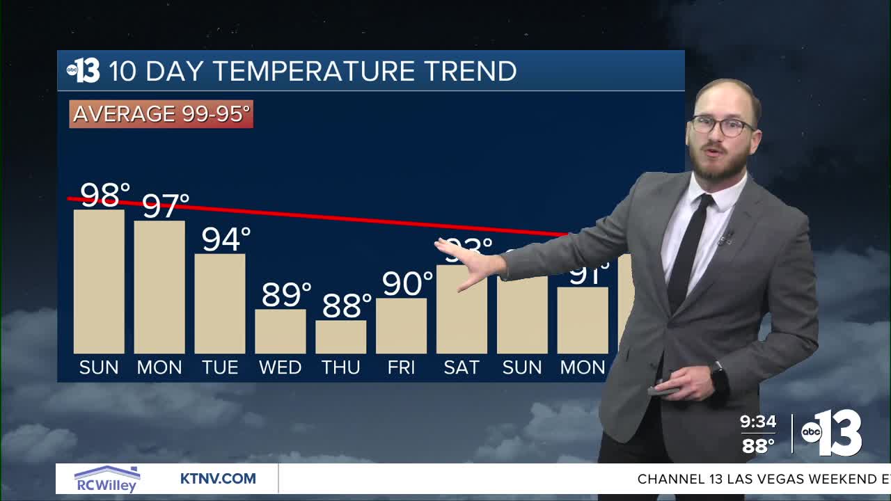
TOMORROW: Warmer and drier than the last several days, lots of sunshine, temps in the upper 90s
MONDAY: Temperatures stay in the mid to upper 90s, clear skies
MID-WEEK: Much cooler temps, daytime highs dipping into the upper 80s
_________________________________________________________
After the dazzling light show Mother Nature cooked up for us last night, Saturday was much, much calmer, which will be the trend going forward these next few days.
Before we get there, let's recap the thunderstorms from overnight Friday and into the wee hours of Saturday morning!
WATCH | Overnight thunderstorms give Las Vegas a Friday night light show
Strong thunderstorms developed west and northwest of the Las Vegas Valley before midnight and created the most lightning in the night sky in recent memory. Incredible pictures and videos were sent into us here at Channel 13 from all over town as the storms moved east across northern Clark County.
WATCH | Why did we see so much lightning in our skies Friday night?
As the night wore on, some neighborhoods in the central valley got some sprinkles, but most of the activity was concentrated north.
Here's a look at some rain totals from yesterday's thunderstorms:

Saturday was way calmer by comparison, although an isolated thunderstorm rolled through south and southeast parts of Henderson and south of Boulder City between 3 and 4 p.m., which caused the National Weather Service to issue a Severe Thunderstorm Warning, which expired at 4:30 p.m.
That slight shower activity actually was enough to officially record trace amounts of rain at Reid Airport. Here are some other rain totals from the southeast valley Saturday afternoon:

Saturday's official daytime high at Reid Airport was 95, four degrees shy of our average high of 99. Overnight lows Saturday will be in the upper 70s and low 80s.
Sunday will be warmer and drier than the last several days, as westerly flow replaces the southerly flow that was funneling monsoonal moisture into our atmosphere. Expect mostly clear skies and lots of sunshine, with daytime highs in the upper 90s through most of our neighborhoods.
As we look ahead, an area of low pressure from the Pacific Northwest will start to extend down towards our neck of the woods and begin to cool our temperatures even further, anywhere between five and 10 degrees below normal.
In fact, we're forecasting daytime highs in 80s by Wednesday and Thursday, if you can believe it! Overnight lows will be seasonably cool too, dipping down around 70, and maybe even below it at times.
We'll warm up a bit after that, but will still stay below normal for the next week to 10 days with lots of sunshine and dry conditions. Breezes might pick up a bit with the low pressure, but shouldn't be a major factor in our forecast, at least as of right now.
Have a great rest of your weekend!
