

THIS MORNING: Chilly with light showers across much of the Las Vegas Valley, dry by late morning
THIS AFTERNOON: WINDY! Gusts upwards of 50 mph possible, temps in the low to mid 50s
TONIGHT: Chilly overnight lows in the low to mid 30s (wind chills will make it feel colder), still staying windy
TOMORROW: Coolest temps of the forecast period in the upper 40s and low 50s, still windy but not nearly as significant as Thursday
THIS WEEKEND: Much calmer weather pattern ahead, clear skies and temps in the mid to upper 50s
_______________________________________________________
We've got a very busy weather day ahead in Southern Nevada, with some light rain to kick off our morning and extremely gusty winds dominating headlines the rest of the day.
Showers started to roll in across Clark County and into the Las Vegas Valley around 7 a.m., but precipitation totals have remained light. Reid Airport is reporting .03" as of 8 a.m., but the northwest parts of town saw the bulk of the rain, with totals through some neighborhoods in Centennial Hills approaching 0.1" as of 8:15 a.m.
This quick band of showers on the leading edge of this cold front should move through Clark County by the noon hour today, giving way to the main weather headline for Thursday: extremely gusty winds.
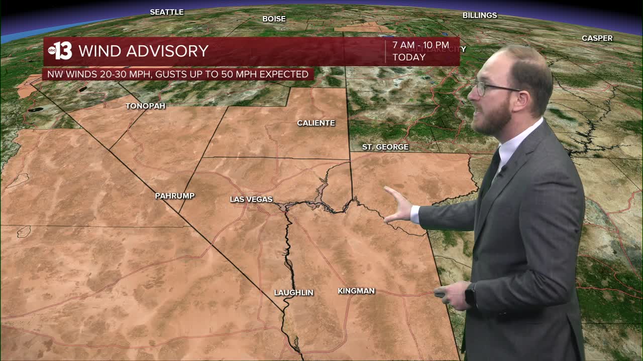
The National Weather Service has a Wind Advisory in place for Clark, Lincoln and Southern Nye counties until 10 o'clock tonight, for sustained winds from the northwest at 20-30 mph, with gusts upwards of 50 mph possible for our forecast area.
Gusts are expected to pick up substantially on the back end of the cold front this afternoon, but Reid Airport has already recorded wind gusts exceeding 50 mph as of 8:30 this morning.
Once winds pick up, they should stay steady through the evening and overnight hours, but will start to calm down as we kick off your Friday morning.
As with any strong wind storm, expect lots of blowing dust and debris — which could hamper air quality and visibility on our roads — strong crosswinds on freeways and the potential for power outages around the valley.
Daytime highs today through our neighborhoods will be in the low to mid 50s, with chilly overnight lows in the mid 30s — made to feel 5-10 degrees colder by the wind chill.
As we look towards Friday, it'll be windy, but winds will be calmer than they'll be today, with gusts north of 30 mph still possible, and will be far less of a factor in our forecast this weekend.
Friday temps will be colder than Thursday, with highs in the upper 40s and low 50s through Southern Nevada, and lows near freezing, once again with wind chills making it feel colder than it actually is.
As we take a look ahead to the weekend, temperatures start a warming trend back into the mid to upper 50s as our weather pattern calms down, with dry conditions, more sunshine and calmer winds.
I know it's hard to feel it with how blustery it is today, but temperatures will return to the mid to upper 60s one week from today.
Have a great Thursday, and try not to blow away!
