

TONIGHT: Mostly clear skies, temperatures dipping down into the low to mid 60s
TOMORROW MORNING: Chilly start to the morning, temps in the 60s and low 70s
TOMORROW AFTERNOON: Sunny skies, daytime highs in the upper 70s and low 80s
TOMORROW EVENING: Cooling down into the mid 60s overnight once again
NEXT WEEK: Staying dry and mostly sunny, warming back up into the mid to upper 80s by mid-week
______________________________________________________
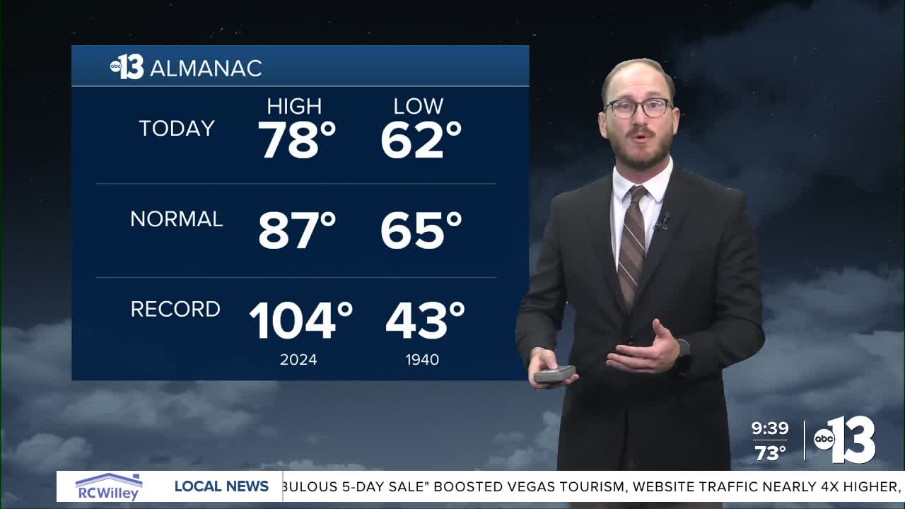
You can't ask for much better weather than what Mother Nature has gifted us for the first weekend of October!
Saturday's daytime high was 78 degrees at Reid Airport — that's nine degrees below our normal high for October 4, which is 87.
It was a completely different story a year ago, when we set the all time hottest temperature ever recorded in October for Las Vegas, and the hottest temperature this late in the year, at 104.
October 4, 2024 was also smack dab in the middle of a stretch of five consecutive records to kick off the month — from October 2 through 6 — and eight records in nine days to end September and start October, just another reminder that 2024 was indeed the hottest year on record.
With that added context, October 4, 2025 was 26 degrees cooler than the year before. Pretty insane stuff!
Sunday will look like a carbon copy of Saturday, just a few degrees warmer: clear skies, lots of sunshine and virtually no wind to speak of outside of a light breeze or two in the afternoon. Expect an official high temperature of 81 at the airport, with our neighborhoods hovering in the upper 70s and low 80s.
Temperatures will continue to warm up back closer to normal by mid-week, comfortably into the mid 80s by Tuesday and Wednesday, knocking on the door of 90 with 89 forecast for Thursday. Expect lots of sunshine, with barely any wind to speak of next week. Overnight low temperatures will be in the mid 60s, so the characteristic early-fall beautiful desert evenings aren't going anywhere.
As we look about a week out, recently formed Tropical Storm Priscilla off the west coast of central Mexico could influence our weather pattern next weekend. It's still way to early to tell just how far north Priscilla will track and how strong the storm will be, but early model runs are showing the tropical instability from Priscilla could interact with an incoming trough of low pressure off the coast of the Pacific Northwest moving inland by the end of next week and into the weekend and increase our rain chances.
Again, far too early to say with any sort of confidence that we will get rain here in Southern Nevada, but this weather pattern is certainly something we're keeping our eye on as we wrap up the weekend and enter the work week.
Have a great weekend!
