


LAS VEGAS (KTNV) — Summer in Southern Nevada means extreme heat and the start of monsoon season.
The Las Vegas Valley had an early start to monsoon season, with rapidly developing strong thunderstorms over the first week of June — was that a preview of what's to come later this summer, or are we on track or another "non-soon" season?
This is what experts have to say
Unfortunately, the answer is "maybe."
National Weather Service (NWS) Lead Forecaster Chris Outler says a low pressure system in early May — which set the record for our wettest May ever — didn't resemble a monsoon pattern, adding we kind of "got lucky" in June, with moisture making its way up to the desert southwest due to tropical activity in the Eastern Pacific.
"The correlation isn't especially strong," Outler said. "It doesn't mean it's necessarily going to continue to be active, but we'll see how it goes — we could certainly use the rain for drought purposes."
So far, the Weather Service is projecting a pattern shift towards monsoonal activity for the first week of July, bringing 40 to 50% chances for above-normal precipitation to the valley.
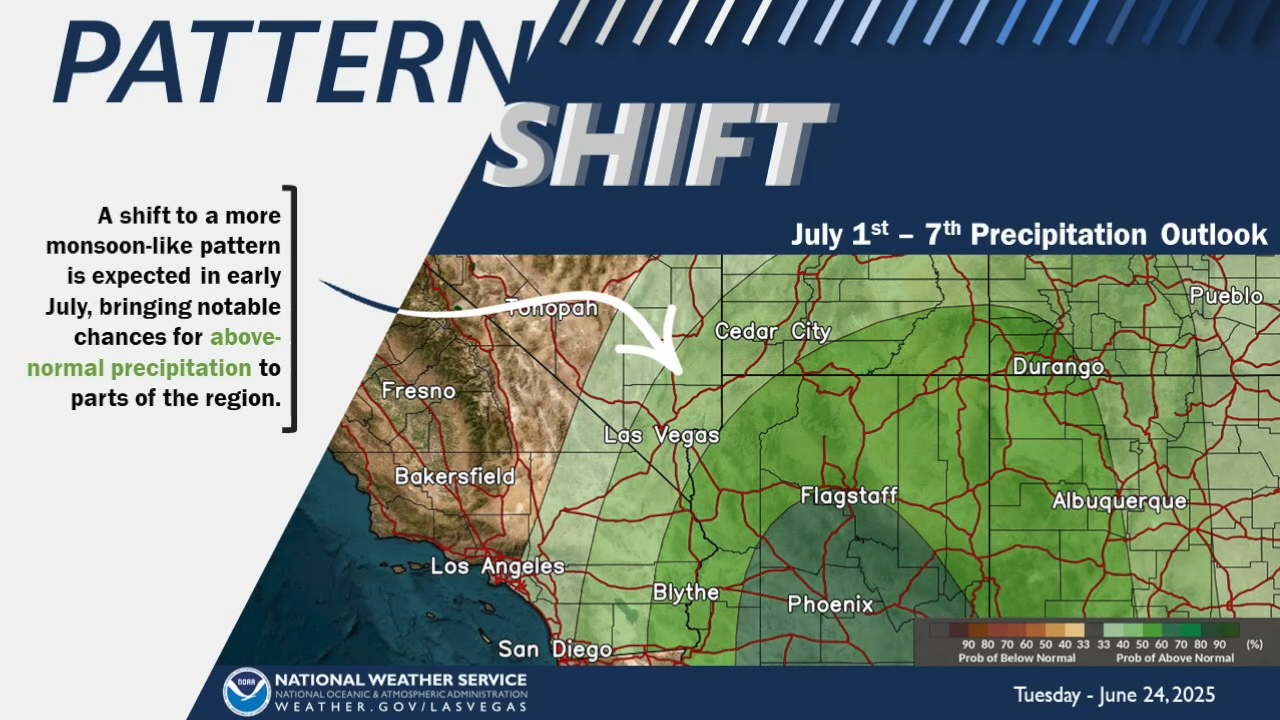
Beyond that, though, it gets a little more murky when it comes to this monsoon season.
"The official outlook calls for no particular or favored outcome," Outler said. "It could be equal chances of wetter, drier or near-normal conditions."
Outler says he understands that answer might be a bit unsatisfactory, but adds their monsoon outlooks are based on analyzing our weather patterns, such as if we're in an "El Niño" or "La Niña" pattern.
"This year, we're kind of in a neutral pattern, so we don't really have that to hang our hat on," Outler said.

Local News
Sizzling temps, potent storms: Your guide to summer weather in Southern Nevada
Heat grabs most summer headlines, but monsoons can be a serious threat to safety, too
A lot has been made about last year's "non-soon," where we saw very little moisture in Las Vegas, so that begs the question: what was our forecast outlook at this time last year?
"I think we had a similar forecast, we didn't have one preference one way or another," Outler said. "The year prior to that we got a ton of rain, and there wasn't a clear indication that's how it was going to work out either. We're always a little surprised with the monsoon, it has a character of its own, and we kind of have to roll with it and see how it plays out."
That means it's extra important to be on alert for flash floods, even in off-season months, like we saw in May and June, according to Regional Flood Control District General Manager Andrew Trelease.
"There were a couple people that got swept up in the floods in those events," Trelease said. "It just goes to show you that any time of the year floods can happen."
If we do see an uptick in monsoonal moisture this summer, Trelease says the Flood Control District is ready for it, highlighting their 713 miles of storm drains and flood channels across the county, including their 111 detention basins — their newest being built in the far-east valley near Owens Avenue and Los Feliz Boulevard at the foothill of Frenchman Mountain is expected to be completed this November.
"We've made a lot of progress and we're very proud of what we've done," Trelease said. "What we have accomplished and what we have in place right now is really good protection for Clark County residents and visitors."
Heading into monsoon season, the message is always clear: stay out of detention basins and flood channels, and if you see flooded out roads, turn around don't drown — water always wins.
For more information and flood safety tips, visit the Regional Flood Control District's website by clicking here.