

CASTLE ROCK, Colorado — Instead of chasing stars or exploring new worlds, a growing number of innovators are launching satellites to protect our own Earth, in a new kind of “space race” to spot wildfires before they spread.
More than 50,000 wildfires burned across the U.S. this year, according to the National Interagency Fire Center, as the duration and intensity of fire seasons continue to grow. The expansion of what used to be a regional threat into a year-round crisis is stretching first responders, and budgets, dangerously thin.
New satellite networks under construction to ultimately scan the Earth in near real time offer firefighters faster alerts and better coordination, when every second counts.
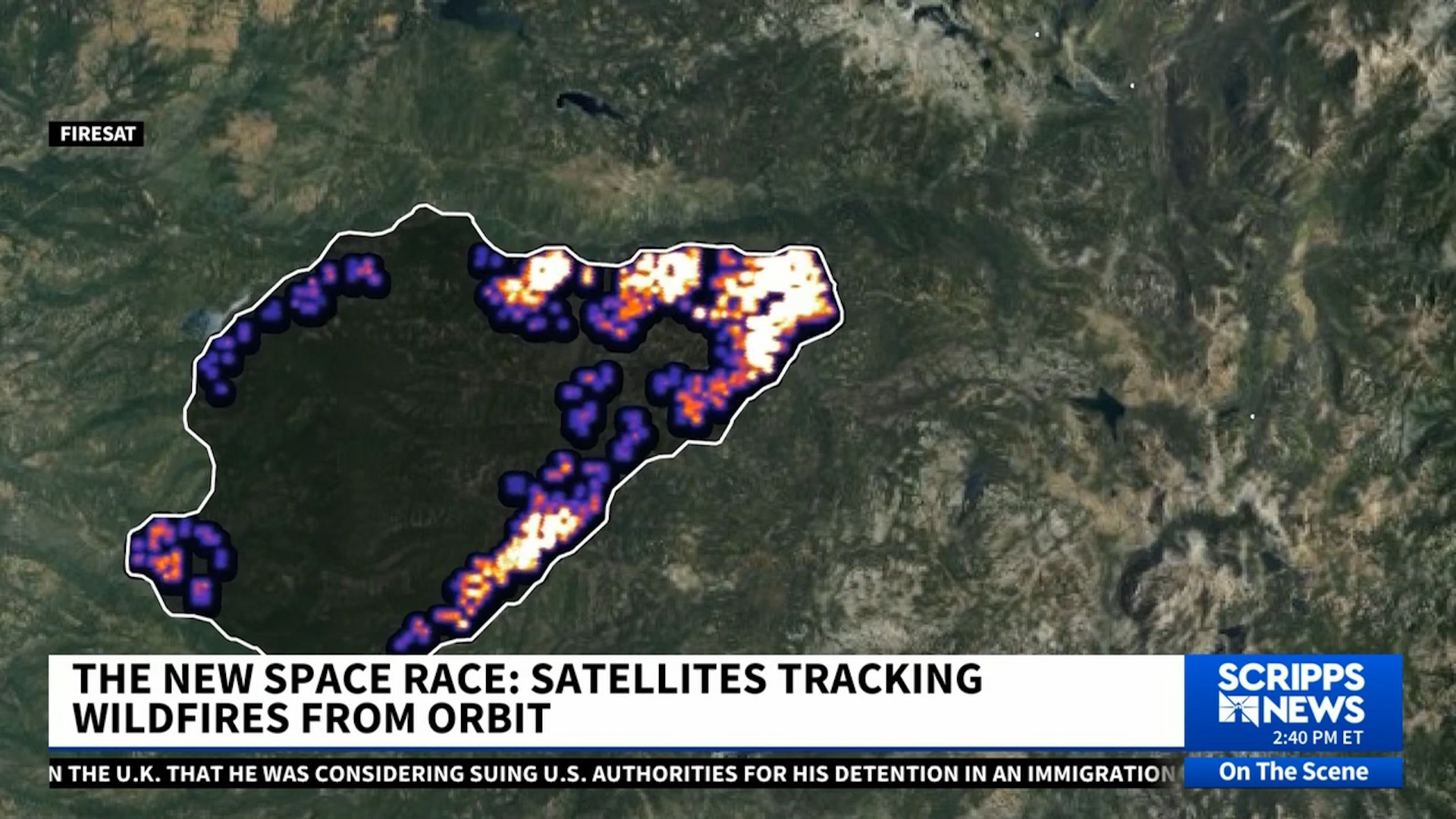
“Wildfires are a big and growing challenge,” said Jonny Dyer, CEO and co-founder of Muon Space, the company behind a new network of satellites known as FireSat, in partnership with non-profit Earth Fire Alliance. “They’re changing behavior, they’ve become much more extreme and much more damaging. The finite resources the fire agencies have is a really critical problem: they just haven't had the overhead persistent situational awareness of where the fires are, how intensely they're burning, how they're moving… that's really what a constellation of satellites like this can solve.”
The FireSat team is building what they call a global constellation of satellites to deliver wildfire updates from anywhere on Earth, roughly every 20 minutes. Their goal is to launch more than 50 satellites into orbit by 2030. Using advanced infrared sensors, the satellites can detect heat signatures as small as five square meters, about the size of a compact parking space or a small classroom, within moments of ignition.
RELATED STORY | Newsom says Trump climate-fighting absence is 'doubling down on stupid'
Various states and fire agencies have tried to add extra tools to their practices in recent years, like drones, small aircraft, and AI-equipped high-level cameras. But, Dyer argues these methods are too local, and sometimes limited, citing high winds or bad weather as a factor that could interrupt their utility.
“Satellites don’t suffer any of those problems,” he explained. “They’re always available, and they’re also global. If California spends a lot of money for a couple of aircraft, that’s great for California, but it doesn’t help Nevada or New Mexico or Canada, which are also suffering from fires.”
In one recent test, FireSat identified two side-by-side grass fires in Oregon almost immediately after they sparked along a roadside.
“We believe it was something like a spark from a car or a cigarette,” Dyer described. “You can think about this as it’s seeing the heat signature of a fire.”

While FireSat’s devices, along with satellites from competitor OroraTech, do their work from low-Earth orbit, others are experimenting with stratospheric solutions — within Earth's atmosphere.
Sceye, an aerospace company founded by Mikkel Vestergaard Frandsen, designed a solar-powered, helium-filled aircraft that floats about 65,000 feet above Earth’s surface.
“We’d be able to offer coordination and eyes on everything from the stratosphere,” Frandsen told Scripps News. “We’re also flying with massive antennas that offer 4G or 5G LTE, which offers the ability for responders to talk to each other and see everything that goes on.”
Each Sceye balloon can monitor up to 75 square miles at a time, slightly larger than the city limits of San Francisco, giving firefighters an uninterrupted view of how a blaze evolves in real time.
The aerospace startup recently announced a partnership with NASA and the U.S. Geological Survey to deploy their climate management tools.
The partnership between public and private ventures is essential in Brian Collins’ eyes, especially in light of budget cuts to NOAA and NASA. He’s the executive director of the Earth Fire Alliance, the nonprofit arm of the FireSat project, establishing early adopter partnerships with fire departments across Oregon, California, Colorado, Portugal and Australia.
We're complementary to the big large scale systems that we have,” Collins told Scripps News. “Our new space industry is merging public and private systems to meet a problem. It's a layered integration of those systems. We can service a very specific mission-focused need; the large-scale research can still occur and should still occur at a national level.
FROM THE ARCHIVES: The catastrophic fires that incinerated Lahaina in Hawaii
The goal of working with the early adopters is to lay a blueprint that could work for other departments as the satellite constellation grows, and they eventually hope to make the same real-time data available to the public, similar to how hurricane radars are shared today.
“We believe that the world is safer if both the public and your fire department have information to act on,” Collins explained. “It shouldn't just be one or the other. The public has a role in their own safety, too.”
