


LAS VEGAS (KTNV) — Following an active Thursday of weather events, more showers and storms with flooding chances are expected across the Southern Nevada region for Friday.
Channel 13 is monitoring weather updates as we expect isolated storms throughout the afternoon.
Check out the 3 PM forecast from Meteorologist Linh Truong.
UPDATES
2:28 p.m.
The NWS issued a flash flood warning for parts of the northwest Las Vegas Valley until 4:45 p.m. as heavy rainfall continues. Some rain gauges have seen more than one inch of rainfall.

2:10 p.m.
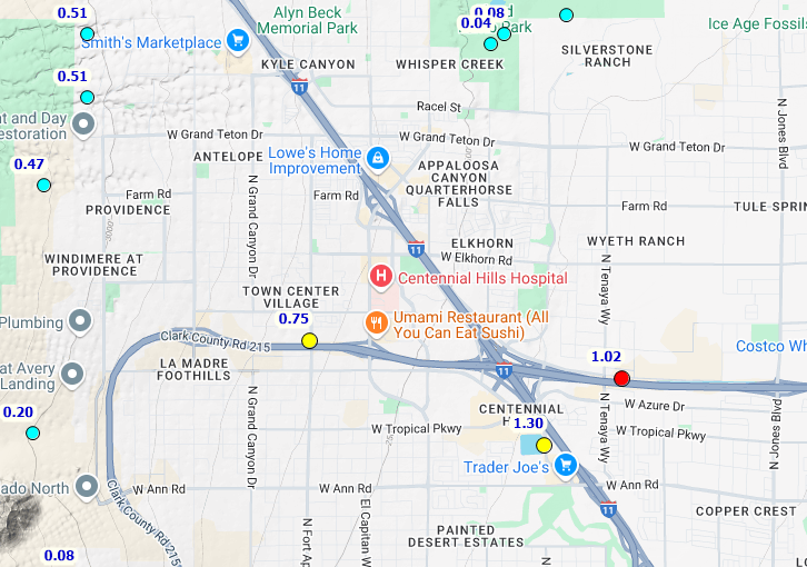
The NWS said some locations in the northwest valley are seeing nearly an inch of rainfall within the past hour alone. One gauge from the Clark County Regional Flood Control near Interstate 11 (U.S. 95) and CC-215 shows 1.30".
1:48 p.m.
The NWS issued a flood advisory for much of the northern and northwest parts of the Las Vegas Valley, including Las Vegas, North Las Vegas, Aliante and Fremont until 4:45 p.m.
They advise travelers to watch for significant ponding on roadways and washes will fill up quickly. Do not travel through flooded streets.

1:20 p.m.
The NWS issued a flash flood warning for areas in the northwest Las Vegas Valley, including Highway 157. They said heavy rain is present and localized flash flooding is possible through 4:15 p.m.

12:11 p.m.
The National Weather Service Las Vegas field office issued a flood advisory for portions of the Spring Mountains until 3:15 p.m.
This includes Highways 156, 157 and 158. NWS says expect heavy rain and possible flooding.
